


Cicerone Italië & Malta|Wandelgids Trekking the Giants Trail – Alta Via 1
Original price was: €26.68.€20.14Current price is: €20.14.
Praktische Engelstalige wandelgids van de Alta Via 1 een tweeweekse huttentocht (180 km), die van Donnas naar Courmayeur loopt. Met overzichtkaartjes, accommodatie met contactinformatie en alternatieve routes. Als kaartmateriaal worden kaarten van IGC aanbevolen.
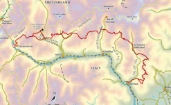
Guidebook to trekking Italy’s Alta Via 1 – a 180km trail through the Italian Alps, following the northern flank of the Aosta Valley from Donnas to Courmayeur. Nicknamed the Giants’ Trail, the route offers fantastic views of the Alpine giants: Mont Blanc, the Matterhorn and Monte Rosa. With travel advice and accommodation listings.
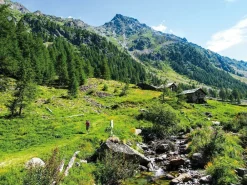
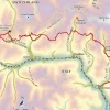
Italy’s Alta Via 1, a 180km trail through the Italian Alps following the northern flank of the Aosta Valley, boasts magnificent views of the Alpine giants: Mont Blanc, the Matterhorn, the Grand Combin and Monte Rosa. Indeed, it is sometimes known as the Giants’ Trail and can be combined with a sister-route, the Alta Via 2 (covered in a separate Cicerone guide), which runs along the southern flank of the valley, to form the Tor des Géants. Stretching from Donnas to Courmayeur, the Alta Via 1 offers fantastic alpine walking, with welcoming refuges and small hotels providing overnight accommodation (and great food) along the way.
The guide presents the route in two sections, for the advantage of those who can’t spare the full fortnight-plus needed to walk the entire AV1. The trail is described in 16 stages, with alternative stages covering some popular variants, including an optional detour to visit the famed monastery at the Great St Bernard Pass. Each stage includes clear route description and mapping, plus notes on local points of interest and accommodation options. An alternative itinerary, list of useful contacts, kitlist and glossary can be found in the appendices.
The AV1 crosses cols of nearly 3000m as it traverses the side-valleys of the main Aosta Valley. Suited to those with some of experience of alpine trekking, the walking is demanding but without technical difficulty. And the rewards are many: quieter huts, breathtaking vistas and a chance to immerse yourself in fabulous mountain landscapes overlooked by soaring, snow-clad giants.
The Alta Via 1: An Italian Haute Route
Eastern section
- Stage 1 Donnas to Sassa (Etoile du Berger)
- Stage 2 Sassa (Etoile du Berger) to Rifugio Coda
- Stage 2A The Col Portola Route: Sassa (Etoile du Berger) to Rifugio Coda
- Stage 3 Rifugio Coda to Rifugio Barma
- Stage 4 Rifugio Barma to Niel (La Gruba)
- Stage 5 Niel (La Gruba) to Gressoney-Saint-Jean
- Stage 3A Rifugio Coda to Rifugio della Vecchia
- Stage 4A Rifugio della Vecchia to Rifugio Rivetti
- Stage 5A Rifugio Rivetti to Gressoney-Saint-Jean
- Stage 6 Gressoney-Saint-Jean to Rifugio Vieux Crest
- Stage 7 Rifugio Vieux Crest to Rifugio Grand Tournalin
- Stage 8 Rifugio Grand Tournalin to Cretaz, Valtournenche
Western section
- Stage 9 Cretaz, Valtournenche to Rifugio Barmasse
- Stage 10 Rifugio Barmasse to Rifugio Cunéy
- Stage 11 Rifugio Cunéy to Closé/Oyace/Lexert
- Stage 12 Closé/Oyace/Lexert to Ollomont/Rey
- Stage 12A Closé/Oyace/Lexert to Ollomont/Rey: the low route
- Stage 13 Ollomont/Rey to Rifugio Champillon
- Stage 14 Rifugio Champillon to Saint-Rhémy-en-Bosses
- Stage 15 Saint-Rhémy-en-Bosses to Rifugio Bonatti
- Stage 15A Via Francigena from Saint-Rhémy-en-Bosses to Great St Bernard Monastery
- Stage 15B Great St Bernard Monastery to Rifugio Bonatti
- Stage 16 Rifugio Bonatti to Courmayeur
- Appendix A Alternative schedule
- Appendix B Useful contacts
- Appendix C Useful phrases
- Appendix D Kit list
Bekijk alle
PRODUCTINFORMATIE CICERONE WANDELGIDS TREKKING THE GIANTS TRAIL – ALTA VIA 1
Be the first to review “Cicerone Italië & Malta|Wandelgids Trekking the Giants Trail – Alta Via 1”
Related products
Boeken & Kaarten
Boeken & Kaarten
Boeken & Kaarten
Boeken & Kaarten
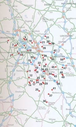
AA Publishing Groot-Brittanië & Ierland|50 Walks in Warwickshire & the West Midlands
Boeken & Kaarten
Michelin Groot-Brittanië & Ierland|Groene Reisgids Weekend Edinburgh
Boeken & Kaarten
Boeken & Kaarten
Boeken & Kaarten
Bantam Press Groot-Brittanië & Ierland|A Curious guide to London
Login
Reviews
There are no reviews yet.